By guest contributor Barbara Bennett
The dynamic power of God’s creation will be on display with the next cycle of king tides. How high will the December-January king tides be? To answer, we will be wise to predict with one eye looking at historic patterns and the other looking at emerging new patterns.
Now is an ideal time to consider:
- What we know about annual king tides,
- What we can – and cannot – predict for the 2025-2026 cycle, and
- Options shoreline property owners might consider to increase safety and resilience as good stewards of their privately owned shoreline.
WHAT DO HISTORIC RECORDS TELL US ABOUT KING TIDE PATTERNS IN THE PAST?
The ingredients that drive weather events, and eventually shape climate, are well established.
Historic records track air and water temperatures, evaporation and air saturation, storms and winds.
We know king tides cycle through late December and early January each year and the tides are influenced by many conditions. The chart above illustrates conditions that influence the height of tidal cycles including geological factors, historic and projected tidal heights factoring in sea level rise, and storm surge. (Please note that sea level rise is among the factors.) Looking back at historic tidal heights around Island County, provides a helpful baseline for what has been normal …in the past.
The ingredients of weather and climate are generating more frequent and more intense storms caused by rising global air and water temperatures beyond historic fluctuations. It’s NOT past norms that warn of the most danger; it’s the peaks of extremes that are most damaging and dangerous.
WHAT ARE EMERGING FACTORS THAT INFLUENCE FUTURE PREDICTIONS?
Emerging patterns of extreme storms include:
- increasing wind and wave energy – threatening structures on the shore and inland
- increasing intensity of rainfall (i.e. short duration deluges) – increasing the potential of inland and shoreline flooding and
- extremely low air pressure (barometric readings) – which increases the height of sea level carried by storm surge.
HOW HIGH WILL THE NEXT KING TIDES BE?
This seemingly simple question has a complicated answer –It all depends on timing. If an extreme storm overlaps a king tide, then both add to the total tidal height.
THAT’S WHAT HAPPENED DURING THE KING TIDE ON DECEMBER 27, 2022 – read on for details.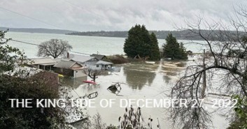 Tide tables predicted the winter king tide on the night of December 27, 2022, would peak in the Seattle area at 1.37 feet above MHHW (Mean High High Water) – the highest tides in 40 years. These predictions though, based on long term historic patterns, only told part of the story.
Predictions based solely on historic data could not have anticipated that a storm brewing over the Pacific would coincide with the extreme tide, would drive barometric pressure to an extreme low that added 2 feet in sea level, and be driven by southerly winds that would push the storm surge directly onto Whidbey’s western shores.
The combined tidal peak plus storm surge as measured by the NOAA Port Townsend station that night would be a dangerous and unprecedented 3.5 feet above MHHW.
The tide reached its peak in the dark of night. Shoreline owners woke to find this extremely high tide had caused significant damage to structures around Island County and Puget Sound: Roads, septic drain fields, utility lines, and basements were flooded, and some wells were inundated with saltwater making them unusable.
https://oceanservice.noaa.gov/news/jan23/december-2022-record-water-levels.html
This king tide raised many questions for discussion around kitchen tables:
- Was this high tide a fluke of nature or will future king tides be even more extreme?
- Would it be wise to change thinking and strategies about living close to the water?
- What are responsible options for owners to consider re: ownership, stewardship, resilience?
- And does our Christian literature describe risks associated with living close to the water?
(Surprisingly, yes: Christ used these risks to illustrate his parable in: Matthew 7: 24-27)
LOOKING AHEAD
Predictions are for increasingly intense and destructive storms and tides impacting Island County and the sea level itself will gradually press landward day-to-day and to new levels in extreme events. Eventually, the ocean will threaten and/ or overpower human-made structures near the water’s edge.
It is preferable to keep a natural buffer between human-made structures and the dynamic and changing edge of the sea. Natural structures including vegetation with its anchoring roots slow down coastal erosion. Human structures close to the water’s edge may compound their risks by interfering with the ecological, protective, and dynamic functions of shoreline landforms, vegetation, material, and sea life.
WHAT ARE OPTIONS FOR SHORELINE OWNERS TO CONSIDER?
The path of least resistance is for shoreline owners to retreat from the water’s edge. Nature’s shoreline structures and functions provide a natural buffer for safety and resilience while dynamically following their innate courses.
Options shoreline property owners might consider:
- CONTACT Island County’s Shore Friendly program which helps shoreline property owners understand the behavior and risks associated with their shoreline; strategies to address safety, resilience, and stewardship decisions; and opportunities for funding assistance. Here is the ISLAND COUNTY SHORE FRIENDLY contact information:
- Kelly Zupich, Shore Friendly Program Coordinator
- Email : k.zupich@islandcountywa.gov
- Phone : 360-678.2349
- https://www.islandcountywa.gov/365/Shore-Friendly-Program
- https://wpcdn.web.wsu.edu/extension/uploads/sites/19/2025/04/2025-Spring-Shore-Stewards-Newsletter.pdf
- elevating structures allowing for anticipated extreme flooding, tides, and storm surges.
- move structures to higher ground, or
- demolish and recycle existing structures and rebuild them on safer ground.
- pay special attention to utilities such as wells, septic systems, and underground power lines.
- Note: Because they are extremely damaging to the shore and will ultimately fail, sea walls and other forms of hard armoring are NOT a recommended or easily permitted option.
In many locations soft shore strategies to buffer properties may be helpful and Shore Friendly will assist exploration of these, and other, options.
Our Prayer: we ask for wisdom Lord as we live on an island that faces future coastal challenges. May our actions of stewardship be pleasing in your sight. Amen.
Thanks for caring!
— Joe Sheldon
Direct comments to Joe Sheldon at jksheldon43@gmail.com
Barbara Bennett and Joe Sheldon are members of Trinity Lutheran Church
Barbara graduated in 2010 with a Masters of Marine Affairs from the University of Washington School of Marine and Environmental Affairs. She coordinated the WSU Island County Beach Watchers program from 2010 – 2015 and serves as an appointed member of the Island County Marine Resources Committee, 2016-present.
Joseph K. Sheldon received his Ph.D. in entomology from the University of Illinois. He is a former professor and head of the Department of Biology at Eastern University (St. Davids, Pennsylvania) and former professor of biology at Messiah University (Grantham, Pennsylvania). He left the position of Chair of the Board for Pacific Rim Institute for Environmental Stewardship (Coupeville, Washington) in August 2025. Sheldon has authored more than twenty peer reviewed articles in science journals and is author of Rediscovery of Creation: A Bibliographical Study of the Church’s Response to the Environmental Crisis and a co-author of Redeeming Creation: The Biblical Basis for Environmental Stewardship.